Build the poster around China’s four major geographic regions
If you want a geography-themed handwritten newspaper about China’s landscapes to look organized and meaningful, a smart idea is to divide the page into North China, South China, Northwest China, and the Qinghai-Tibet Region. This gives the poster a clear geographic structure instead of listing random scenic spots. It works well for primary school projects because the logic is easy to follow.
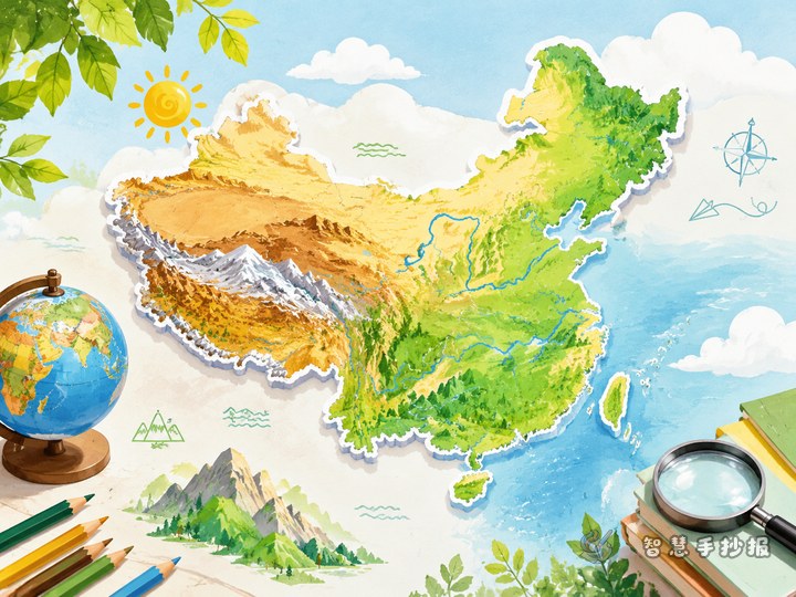
Your main title can be something like “China’s Landscapes: What Are the Four Major Geographic Regions Like?” A smaller subtitle may mention landforms, climate, rivers, and scenery to show the focus of the page.
What to write in each section
North China
- Examples: Loess Plateau, North China Plain, Northeast China Plain, Changbai Mountains
- Feature sentence: This region has obvious seasons, broad plains, and many important farming and industrial areas.
- Useful note: The Yellow River helps shape the bold and powerful northern landscape.
South China
- Examples: Middle and Lower Yangtze Plain, Jiangnan hills, Wuyi Mountains, Pearl River basin
- Feature sentence: The climate is warm and humid, with many rivers and lakes and beautiful green scenery.
- Useful note: The Yangtze River connects many cities and natural landscapes across the south.
Northwest China
- Examples: Tianshan Mountains, Kunlun Mountains, Tarim Basin, deserts and grasslands
- Feature sentence: This region is drier, wider, and known for snowy peaks, open land, and deserts.
- Useful note: It shows a grand and powerful side of China’s natural beauty.
Qinghai-Tibet Region
- Examples: Qinghai-Tibet Plateau, Himalayas, Three-River Source Area
- Feature sentence: This high-elevation region is called the “Roof of the World” and is famous for snow mountains, glaciers, and plateau lakes.
- Useful note: Many major rivers begin here, so it has great geographic importance.
Small poster sections you can add
Besides the four main panels, you can include a few short boxes to make the page look fuller and more interesting.
- Geography facts: China’s terrain is higher in the west and lower in the east.
- Landscape highlights: For example, the Qinghai-Tibet Plateau is very high, and the Yangtze River is China’s longest river.
- My view of China’s landscapes: Write one or two short lines about loving your country and its natural beauty.
- Key terms: landform, climate, river, plain, plateau, basin, hill.
These sections do not need to be long. Two or three simple sentences are enough if they are neat and easy to read.
How to arrange the page
A practical layout is a central title with four surrounding sections. Put the main title in the middle and place the four regional panels around it. This makes the page balanced and gives it a strong geography style.
- Color ideas: use earthy yellow and dark green for the north, light green and blue for the south, orange and brown for the northwest, and blue and white for the plateau region.
- Border ideas: draw mountains, river lines, clouds, sunshine, or a simple outline map of China.
- Writing tip: make the title bold, use colored labels for each section, and keep the body text neat.
If you are short on time, do not make the drawings too complicated. Clear sections, tidy handwriting, and matching colors are already enough to create a strong result. After collecting your text ideas, you can also continue refining the poster in the Zhihui Shouchaobao WeChat mini program.
A simple ending that fits the theme
The closing part does not need to be overly emotional. A short summary works best: China has rich and diverse landscapes, and each geographic region has its own landforms and scenery. Learning geography helps us understand the beauty and greatness of our country.
This kind of ending connects well with the four-region structure and makes the whole poster feel complete.